martedì 31 dicembre 2013

The Erongo Mountains & the Spitzkoppe (2)


The nearby Erongo massif succeeded in erupting as a true volcano, belching out molten rock and ash for a believed 20 million years, before collapsing, forming today's caldera.
Further north, Namibia's highest mountain, the Brandberg, ascends nearly 8,320 ft 
(2,600 m) at its highest peak named Konigstein, meaning "King's Rock" in German, above the desert floor.


The mountain is striped with black stripes made of iron and manganese known as "desert varnish".

The Erongo Mountains are home to hundreds of San rock paintings, simple reminders of Namibia's first inhabitants some 6,000 years ago.
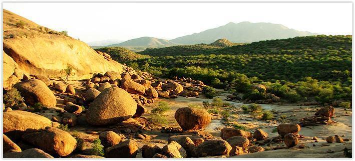
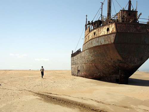
Spitzkoppe
Spitzkoppe is near Swakopmund and is easily reached from the B2 road.
If you are interested in camping at Spitzkoppe or wanting a tour guide to take you to the area, check out Spitzkoppe Campsite.
It's a community operated camp and a member of Nacobta.


lunedì 30 dicembre 2013

The Erongo Mountains & the Spitzkoppe (1)


The Erongo Mountains are just north of the Namib-Naukluft Park, where they rise from the desert floor.

These mountains are uniquely formed as molten magma that never reached the surface and had solidified.


Due to millions of years of erosion, it was eventually exposed.

The main peak of Spitzkoppe now stands at 5,440 ft (1,700 m) above the desert surface and is often referred to as Matterhorn of Namibia.

Tours to Spitzkoppe can be arranged in Swakopmund.


sabato 21 dicembre 2013

The Gravel Plains & the Moon Landscape


One of the largest gypsum surfaces in the world, spreading nearly 10,000 sq. km from the sand sea north to the Swakop River.
It is believed the gravel plains' history begins in the sea.
This theory states the Benguela's pantry of plankton is costantly recycling, dying, and drifting to the bottom of the seabed, where the decomposing material releases hydrogen sulphide into the atmosphere.


In the atmosphere it combines with the oxygen to produce a diluted sulphuric acid.
Fog from the coast then transfers this to the alkaline calcrete of the gravel plains.
The exchange of molecules, as an acid and alkaline mix, creates the gypsum that makes the gravel plains so unique.


Over some 80 million years of weathering and erosion, slicing the gypsum surface into a series of inhospitable canyons, resembling the surface of the moon.

The Moon Landscape
When viewing this Moon Landscape, remind yourself that in early history, the earth's surface was at least a kilometer above where you are standing.
Together water, wind, temperature, chemical, and biological erosion took sediment out to sea.


giovedì 19 dicembre 2013

The Dunes (2)


There is great debate as to whether the dunes are purely created by the sediments washed up from shore, or also from sediment from the Kalahari Desert.
Some geologists believe that a significant amount of the eastern Namib's sediment comes from the red dunes of the Kalahari.


This is possible by the winds blowing in a northeastern fashion during the winter, and consequently the highest dunes and their windward side faces the northeast.
Whatever the case may be, there is no denying the fact that the dunes are special.


mercoledì 18 dicembre 2013

The Dunes (1)

The dunes are like a gigantic beach, and spark a curious question: where does all that sand come from ?
The shifting, dancing sand is a product of both weathering and erosion, originating mostly from the South African hinterland, which are transported to the Atlantic Ocean via the Orange River.


The north-flowing Benguela current then returns the sediment by the powerful ceaseless waves crashing onto Namibia's Diamond Coast.
There it is dried and further thrown inland by the ubiquitous southwesterly winds.
Like other minerals, the desert sand slowly begins to oxidize.
The tiny quartz particles beginning pale, carry iron particles that very, very slowly begin to oxidize.
The coloration begins to change, and the oldest of the dunes turn to deeper shades of red; red with rust.


lunedì 16 dicembre 2013

The Sand Sea


Once in sight of the dunes, it is mind boggling to see what the popular conception of a 
desert is.
The dunes stretch, reach, tumble, and drift across the open nothingness along the Atlantic coast.
Covering 34,000 sq. km and extending from the Kuiseb River southwards to Luderitz, lay the sea of sand.


Beneath the younger sands is an ancient desert believed to have formed some 65 million years ago, eventually becoming petrified between dispersed times of moisture and drought.
These fossilized dunes are easily seen in areas of the NamibRand Nature Reserve and in the proclaimed Sossusvlei area.


sabato 14 dicembre 2013

The Oldest Desert


When compared with the Sahara, the Namib is extremely small.
The Sahara is ten times the size of Namibia and thirty times the size of the Namib.

The Namib is one of the world's most diverse deserts in terms of plant and animal life.
One in every five species in the Namib is endemic, including the ancient Welwitschia plant.


There are four broad types of landscapes to be found: the great sand dune (commonly referred to as the sand sea), the gravel plains, the ephemeral riverbeds, and the inselbergs, or island mountains.

Life in the desert is controlled by the infrequent, unpredictable and isolated downpours that quickly get soaked up by the toughest of life in desperate need for water.


venerdì 13 dicembre 2013

Namib-Naukluft National Park


The Namib-Naukluft National Park is rich in biodiversity, size and attractions.
It is not only one of the oldest deserts in the world, but is Namibia's most versatile area of conservation home to magnificent sand dunes, the gravel plains, and the isolated Erongo Mountains.


Totaling 50.000 sq. km. of protected desert wilderness, its main feature, Sossusvlei, attracts visitors from around the world.
The word "Namib", Nama in origin meaning the "land of our ancestors", contradicts our general perceptions of a desert as a dry, unihabited place with extreme temperatures.


In fact, the Namib was once inhabited by peoples and continues to be so with animals today.
Parts of the Namib can even be cultivated where soil and water are found.
The word "Naukluft" owes its name to the seasonal Tsondab River that, over thousands of years, had eroded and cut a gorge through the Naukluft range during the more humid times in its history.

First named by Afikans farmers as Nou Kloof (Narrow Gorge), it later took its present name Naukluft during Germany's reign.


giovedì 12 dicembre 2013

Skeleton Coast, Accomodation, Skeleton Coast Camp


The camp is run by Wilderness Safaris and reservations need to be booked through them or an agent, as they are the only concessionaire permitted to host lodging in this restricted northern section of the park.

In fact it is only accessible by plane.


Wilderness Safaris has flights every Wednesday and Friday, so a minimum stay of 4 days is required.
The camp has 6 Meru-style tents with spacious bedrooms.
A lounge, bar, and dining area are also on site.


If the weather permits, enjoy your evening meals beneath the old gnarled leadwood tree.
Enjoy the solitude, nearby seal colonies, towering dunes, and diverse wildlife including the desert elephant.


www.wilderness-safaris.com


martedì 10 dicembre 2013

Skeleton Coast, Accomodation, Cape Cross Lodge


This Dutch style hotel has 20 elegant rooms with en-suite bathrooms.
Choose between courtyard or sea front views, only meters from the ocean.


The sea front rooms boast balconies overlooking the cold Atlantic waters.
All rooms have huge bay windows.

The location makes for an easy morning or evening stroll to the seal colony.


www.capecross.org


lunedì 9 dicembre 2013

Skeleton Coast, Eating


Due to the park's remoteness, eating is offered only at the lodges.

If you are, however, staying in Henties Bay, there are two main restaurants in addition to several small takeaways, as well as petrol filling station shops.


To save money, is best to buy yourself a cooler either in Swakopmund or Windhoek and fill it with supplies before heading to the Skeleton Coast Park.


Skeleton Coast (4)

Despite the coast's isolation, it is home to a variety of animals and birds.

On the plains: jackal, oryx, springbok, brown hyena, and ostrich, all maraud.

In the several dry riverbeds: lion, giraffe, desert elephant, and black rhino roam in constant search of vegetation and the sparse spring fed waterhole.

The northern section of the park is part of the concession area, while the south is open to more traveler friendly activities.


Arrival: the best way to visit the Skeleton Coast is with your own vehicle.
It is possible to hire a driver or company to take you there, but it will be rather expensive.

You may consider hiring a vehicle for only a few days to see the place, and then return to public transport or hitchhiking.


domenica 8 dicembre 2013

Skeleton Coast (3)


The landscape is both diverse and alive: vast desert plains are home to large lichen fields and spring into life with the coastal fog, turning the otherwise white-backed dunes into a shade of green.
Over 100 species of lichen grow on the plains and on the westward facing slopes.

The windswept dunes further inland have a plethora of colors, from ivory to maroon.
The maroon coloration is contributed to the garnet sand, while some are even black in color due to magnetite and limonite particles shifting and existing with the ivory colored particles.

The area also hosts rugged canyons, deeply colored volcanic stone, and extensive mountain ranges.


sabato 7 dicembre 2013

Skeleton Coast (2)


The area takes its name from the numerous vessels that fell victim to the coastal rocks.

Bones of countless whales reminiscent of the heydays of heavy whaling fleets, , and the remains of countless tugs, liners and trawlers left to the elements can be seen for miles.


Trees carried downstream during years of extensive rain, lay lifeless in heaps at the mouth.

Together, it seems whatever comes to the area, perishes and leaves only its skeleton.


venerdì 6 dicembre 2013

Skeleton Coast (1)


The Skeleton Coast is one of Namibia's most mysterious and bewitching places.

Europeans feared its incomprehensible size, vastness and isolation, which kept Namibia out of reach to European colonization for so many centuries.

Today, the same feelings are aroused, luring travelers towards the treacherous coastline and large desert wastes.


Beginning in the far northwestern corner, bordering Angola from the Kunene River, the desert stretches along the Atlantic coast until it touches the northern side of the Ugab River to the south.

The narrow tract of desert is approximately 40-50 km wide and 500 km long.

In 1971 it was declared a nature reserve , and today the nature conservation authorities manage its wilderness with tight regulations, limiting both development and the number of visitors able to enter the area.


giovedì 5 dicembre 2013

Henties Bay (2)


Over 200.000 Cape fur seals call Cape Cross home.

Each year, from April to November, the government sponsors an annual seal cull, which employs several hundreds less fortunate Namibians but unfortunately also kill hundreds of seals each season.


The annual culling sparks controversy and debate each year.
The seal's genitals are sold to the Asian market, the skins are flipped into high quality products for the European market and the meat goes to Taiwan, while the rest goes into cattle feed.

Cape Cross is also home to a very intriguing lichen reserve.
Explore this interesting organism on foot, and watch them come to life with a little sprinkle of water.


martedì 3 dicembre 2013

Henties Bay (1)


Located 80 km north of Swakopmund, Henties Bay is a fishing town popular among anglers (the best way to visit Henties Bay is in your own vehicle).

The Delta of the Omaruru River is here and provides a nutrient rich environment for hungry fish offshore.
It's most popular for Cape Cross (another 46 km north of Henties Bay), whose history dates back to 1485 when Portuguese explorer Diego Cao was the first European to set foot on Namibia.


Here he planted a 2 m high stone cross in honor of king John I of Portugual.
The original cross was taken down by German sailors and taken to the Oceanographical Museum in Berlino, but in 1974 a second cross was replaced in the same spot as Diego Cao's original.
The cross is made of Namibian Dolerite, blending in beautifully with the rocky outcrops.
Cao's original inscriptions can now be read in Latin, Portuguese, English, Afrikaans and German.